Map Reading and Interpretation

ICSE Class 10 Geography · Total Geography · 6 solved questions

Exercise
1Short Answer Questions

State what is indicated by the following symbols about the land use:

(a) Tanks and canals

(b) Open scrub

(c) Stony waste

(d) Causeway

Show SolutionHide Solution↓

(a) Presence of tanks and canals indicates that the land is used for agriculture.

(b) Presence of open scrub indicates that the land is used for sheep and goat rearing.

(c) Presence of stony waste indicates that the land is uncultivable.

(d) Presence of causeway indicates a dry river and desert regions which receive only seasonal rainfall.
2Short Answer Questions

Where are the thickly settled areas located in a village?

Show SolutionHide Solution↓

Thickly settled areas are located over fertile plains and on wide river valleys.

3Short Answer Questions

What does a dendritic drainage pattern indicate about the land?

Show SolutionHide Solution↓

A dendritic drainage pattern indicates that the land has soft surface rock material suitable for agriculture.

4Short Answer Questions

How can the climate of a place be inferred from the topo-sheet?

Show SolutionHide Solution↓

The climate of a place can be inferred from the latitudinal extent of the area covered by the toposheet and the type of natural vegetation found there.

  1. The latitude indicates whether the climate is hot, temperate, or cold. For example, places near 10° N are generally warmer than places near 35° N.
  2. The vegetation also indicates the climate. Dense forests suggest heavy rainfall, while cactus, thorny bushes, and sparse grasses indicate an arid or semi-arid climate.
5Short Answer Questions

What are the factors that affect settlements in an area?

Show SolutionHide Solution↓

The factors that affect settlements in an area are as follows-

Physical factors:

  1. Body of water (transportation routes, water for drinking and farming)
  2. Flat land (easy to build)
  3. Fertile soil (for crops)
  4. Forests (timber and housing)

Human factors:

  1. People who share a common language, religion or culture
  2. Social network or supports
  3. Quality of life
  4. Employment
1Match the following

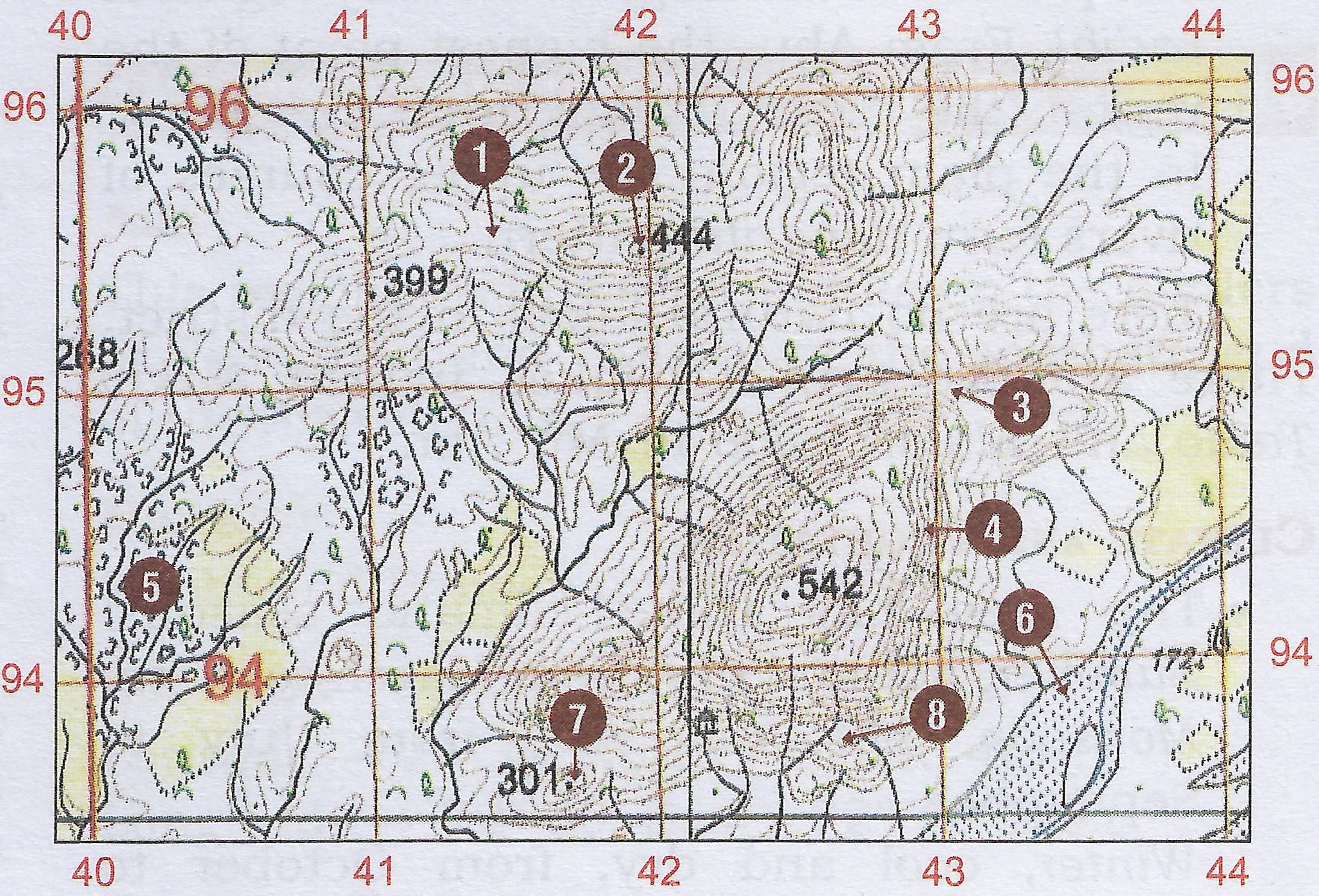
Match the following physical features with the numbers on the extract of the topo-sheet:

Match the following physical features with the  numbers on  the  extract of the toposheet. Map Reading and Interpretation, Total Geography Solutions ICSE Class 10

(a) Dry river bed

(b) Saddle

(c) Steep slope

(d) Pass

(e) Gap

(f) Gully

(g) Knoll

(h) Hill

Show SolutionHide Solution↓

(a) Dry river bed → 6

(b) Saddle → 8

(c) Steep slope → 4

(d) Pass → 1

(e) Gap → 3

(f) Gully → 5

(g) Knoll → 7

(h) Hill → 2

Press ↓ to reveal a solution and move to the next question. Back to Total Geography.

Free sample bank