1
What is a 'map'?
Show SolutionHide Solution↓
A map is defined as a representation of the earth's surface or a part of it, showing natural or man-made features, drawn to scale on a flat surface.
ICSE Class 10 Geography · Total Geography · 8 solved questions
What is a 'map'?
A map is defined as a representation of the earth's surface or a part of it, showing natural or man-made features, drawn to scale on a flat surface.
State the essential features of a map.
The essential features of a map are:
What do you mean by the 'key' of a map?
Key of a map explains the meaning of the symbols that are used in the map. It is also known as legend.
Name the categories into which maps have been classified.
On the basis of size, maps can be classified into two categories:
On the basis of content and purpose, maps can be classified into three types-
What are the topographical maps?
A topographical map shows the surface of the earth in detail. These maps are drawn on a number of sheets where each sheet depicts the details of only one particular part of the whole area. These sheets are joined to give a complete picture of the entire area.
Topographical maps show physical features like valleys, hills, peaks etc., as well as man-made features like roads, railways, canals etc.
What is the National Grid Reference (NGR)?
National Grid Reference (NGR) is a system used to identify the exact location of a feature on a topographical map. It is based on grid lines, which are imaginary lines drawn in red on the survey map. The origin of the grid lies to the south-west of the map.
Give the four-figure grid reference of the following from the given map extract:
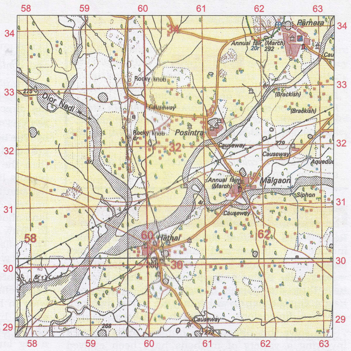
(a) Two settlements having a Post office.
(b) Two settlements having a dispensary.
(c) The Siphon.
(d) The confluence of the main river and Dior Nadi.
(e) The area of Brackish water.
(f) The Annual Fair grounds west of Malgaon.
(a) 6131, 6233
(b) 6234, 6032
(c) 6231
(d) 5930
(e) 6232
(f) 6131
Give the six-figure grid reference of the following from the given map extract:
(a) Police Station.
(b) 4r near the rocky knob.
(c) Post office at Malgaon.
(d) The Surveyed tree at Posintra.
(e) Dispensary north of Posintra
(f) Hospital near Pamera
(a) 625338
(b) 598321
(c) 615312
(d) 600320
(e) 608324
(f) 622340
Press ↓ to reveal a solution and move to the next question. Back to Total Geography.